Seaside and Coastline
The northern boundary of the Exmoor National Park is formed by 24 miles of spectacular coastline on the Bristol Channel.
Starting in the east is the ancient little seaport of Watchet with a mixture of narrow streets, old maritime buildings and a history of Viking invasions. The port was commercially active until quite recently but now has a modern marina with further development of the old harbour area planned for the future.
Proceeding west we come to Blue Anchor Bay, Dunster Beach and Minehead all with popular beaches and facilities for visitors. Minehead beach may become a little crowded at the height of the season but the old town nestled on the slopes of North Hill above the historic harbour is well worth a visit.
Over the heights of North Hill and past Hurlestone Point is Porlock Bay. Once protected by a continuous shingle bank a recent breach has resulted in flooding of the farmland nearest the shoreline. The area is now tidal and a wetland haven for a wide variety of bird life. The picturesque villages of Bossington, Allerford and Selworthy are nearby.
The town of Porlock is a popular destination for visitors with many interesting shops and hostelries to suit all tastes. Slightly further west is the village of Porlock Weir with its’ small harbour and quaint buildings. Accessible on foot over a cliff path from Porlock Weir is the hamlet of Culbone.
The tiny unspoilt church at Culbone is reputed to be one of the first Christian sites in the south west. Lepers used to live and made a living by charcoal burning in the nearby woodland. A small window in the church allowed the lepers to watch church services without going inside.
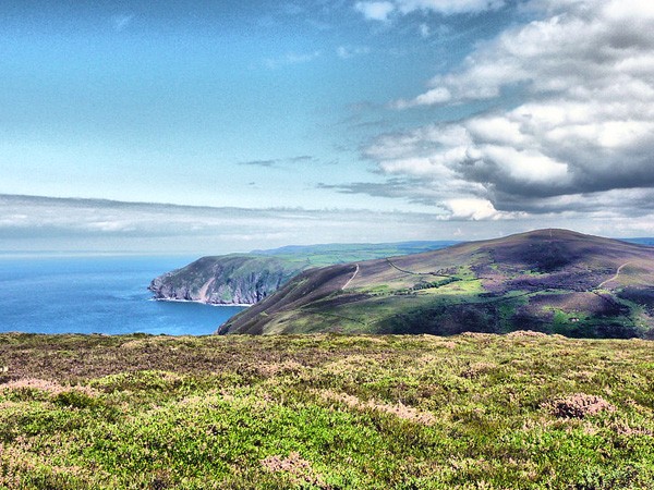
From Porlock the coastline rises to form the highest coastal sea cliffs with the densest coastal forests in the country which extend westward to Combe Martin. The best and sometimes only way to explore this stretch is on foot using the south west coastal path which traverses the area. Remote rock bound bays and coves appear through the oak woodland. Rock pools abound with aquatic life. Water rushes through steep sided combes to the sea.
According to a former German submarine Captain the cove below Glenthorne and County Gate was the preferred spot for collecting fresh water when his U-boat was patrolling the Bristol Channel during the Second World War. A sympathetic housekeeper at the house showed a light in a window when the coast was clear.
The traditional seaside town of Lymouth is located below the cliffs at the mouth of the River Lyn. Step back in time to the heyday of the great British seaside holiday. A little harbour, clusters of balconied buildings and shops stocked with every diversion required to keep the junior family members quiet for an hour or two on the beach.
A Victorian water powered funicular railway transports visitors up to Lynton, another centre for holiday makers. A short walk from Lynton is the amazing geological feature known as the Valley of the Rocks. This waterless river valley parallel to the coast and dry, probably since the last Ice Age, is lined with craggy outcrops eroded in fantastic shapes. Wild goats inhabit the rocky slopes and negotiate the crags with fearless ease.
Moving on we come to Lee Bay where the the stratification of the cliffs visible from the beach gives a fascinating insight to the geological history of Exmoor. Woody Bay a bit further along is a place of extraordinary beauty. Heddons Mouth is the starting point for many exciting walks to the interior of the moor.
The cliffs finally descend past Hangmans Point and there is Combe Martin, a pretty seaside resort with a sandy beach and a wide range of family attractions.
“The northern boundary of the Exmoor National Park is formed by 24 miles of spectacular coastline on the Bristol Channel. “